

|
|
The eagerly awaited 2011 thunderstorm season has begun. For a week GFS had been keen on producing a thundery period over the first weekend of April with the 2nd looking like a prime chase day for much of Ireland and N. Ireland. The latest model runs produced 500-600 CAPE and LIs of -1 over much of the country on a SWly flow in a post frontal airmass which certainly got my attention since SWly flows have always produced the best storms in this country. On the target day the charts still looked good with decent lapse rates and an upper cool pool at - 45 degrees C which was more than enough for large hail and lightning formation. The main restriction was moisture issues and lack of surface convergence however there was just enough wind shear for updraught/downdraught separation which meant cell organisation so the end result could be multicell storms so it all looked quite promising.
I awoke at 08.00 and was delighted to see the sun shinning in a blue sky so there would be sufficient solar heating to generate lift which is always a good thing, you don't want to be waking up to an overcast sky when there are storms forecast because without sufficient lift you can kiss your storm chances good bye. As the morning advanced cumulus streets developed and very slowly they began to turn slightly vertical so things were happening just as expected. The highest CAPE values would not reach central N. Ireland until the 12.00-18.00 BST time frame so there was still plenty of time for things to happen. At midday I called over at Conor McDonald's house and we had a good chat about the potential and spent time studying the radar and sat images however we were getting quite concerned by this point as there was nothing of substance over the country and the sky over Maghera had turned cloudy, cool, and grey which killed our solar heating. Eventually the Sun appeared once again and we could see convection firing, however the clouds were far from impressive and the towers struggled to reach a decent height which underscored my growing feeling that this day could turn out to be a damp squib, I really didn't want the first inland chase day of the year to be a non event so I decided not to give up hope just yet.
By mid afternoon cells had formed over the Republic and in N. Ireland however they were producing nothing so I called over to Declan O'Doherty's house and we spent time yet again looking at the charts, radar, and sat images, soon Conor joined us so all three of us were getting our heads together and working out a chase plan. Sometime later I got a text from Danny Power alerting me to a cell S of Lough Neagh, thunder in Derry, Coleraine, and so began our dilemma of where to go and when, if a poor decision was made and we chased the wrong target it would ruin the day so we spent time thinking everything through. The cell Danny mentioned became high priority, it had been moving SW to NE across the Republic, had passed over the border, and moved into N. Ireland where it could be seen south of Lough Neagh, the sat image looked great and there was a possibility the cell would pass over the Lough itself so a chase to the Ardboe area was looking more and more likely, however just when we were deciding where to go and who was driving I stole a glance out of Declan's window and got a surprise. There was a huge cell over the Sperrins, moving over Glenshane Pass, and heading for the Maghera area, the sky was almost black below it and looked like it was about to turn into a storm at any moment so we all went outside for a look.
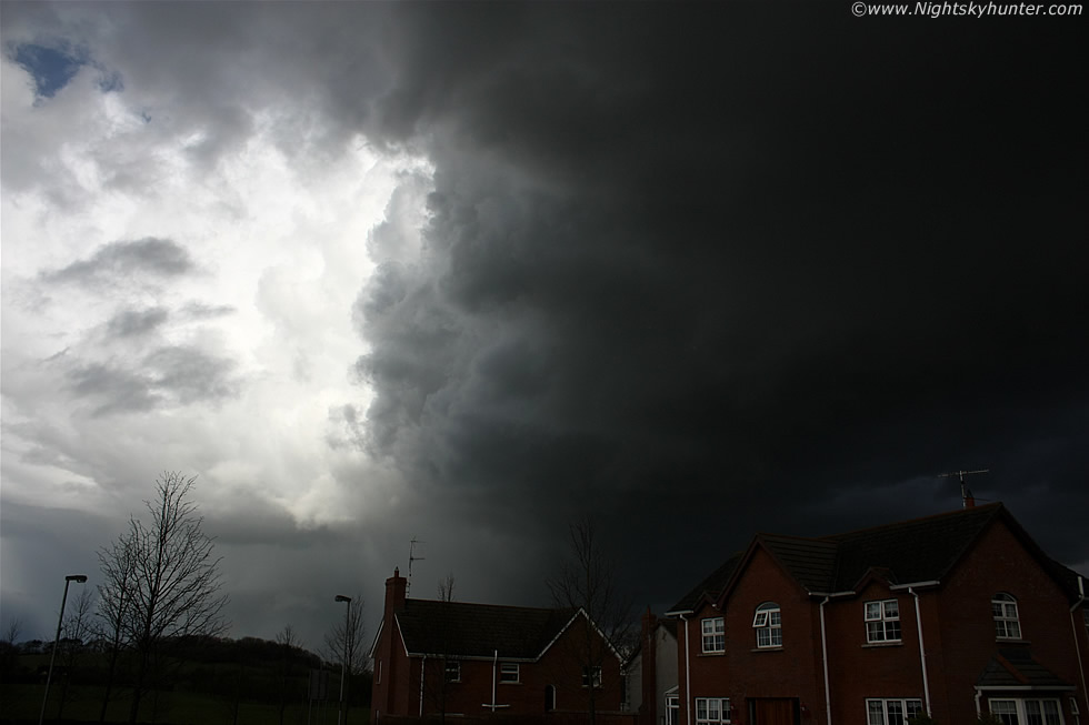 |
We soon forgot about the southern cell as all the action was now happening above our own homes, the three of us just watched from the street as this intense cell advanced from the SW and completely dominated the sky. The cell must have intensified extremely quickly because it became electrified just as it reached Maghera. There was a rapid-fire burst of blue-coloured lightning, they were so quick...strike-strike-strike, must have been 3 or 4 instantaneous bolts with a mix of I-c and c-gs, the I-c kind lashed across a large area of the precip core and Declan saw two c-gs strike the ground, these were followed by several rumbles of thunder at once so it was game on. We were all delighted because we got a sudden storm at home, it's not often one gets rewarded so easily so it was an absolute treat not having to drive across the country in pursuit, it felt like this storm was placed in our hands.
The cell had a remarkable sculptured updraught base which looked very solid and dark and as it passed directly overhead we could see the base rotating in a very striking manner, if you can imagine the sky covered in porridge at the zenith with a giant spoon stirring the mix from below then that's kind of what it looked like with a very pronounced swirling pattern. More thunder rumbled from the precip core to the N then the power went out followed by the noise of car alarms which really added to the atmosphere. The above scene looked visually stunning at the time and the image doesn't do it justice, this is looking at the rear of the storm as it passed over the estate, you can see the vast updraught region in the flanking area (black) feeding into the main updraught of the cell (white) and below is the precip core where the lightning was located. The cloud structure looked rock solid with amazing contrast and we felt certain the updraught could spawn a good funnel cloud at any moment.
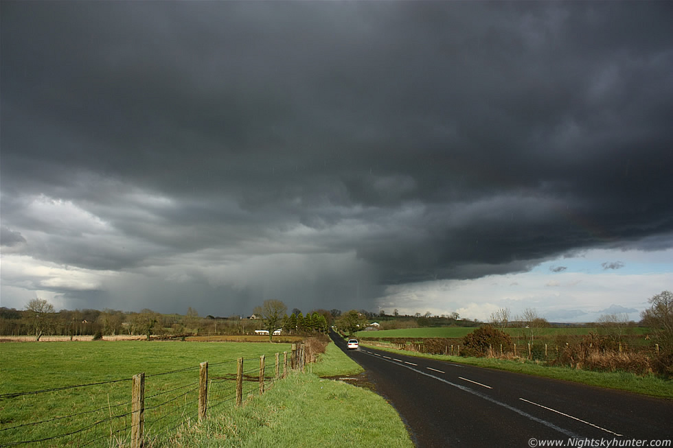 |
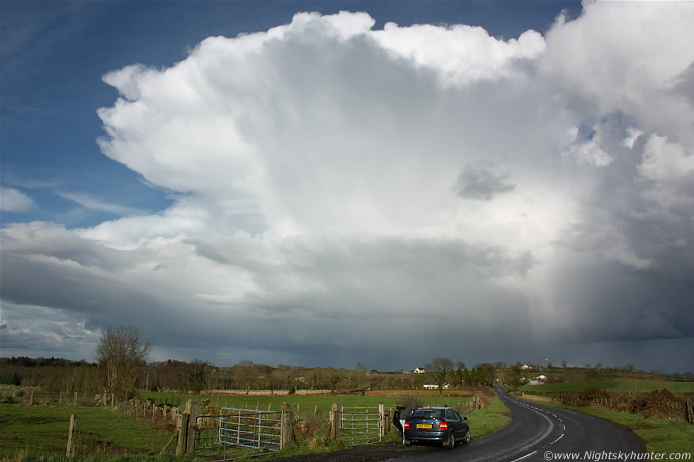
Photo opps were restricted by the built up area so we all got into Declan's car and drove to the countryside and pulled over for a look, and it was from here where we spent much of the afternoon watching the storm. This is looking N at the back of the cell, the precip core was very intense at this time with a few c-gs spotted here and out of frame to the LHS. To the R is the dark flanking line of towers going into the main updraught. The mid section of that base was rotating rapidly with the promise of a funnel cloud which never appeared. You can see the large raindrops streaking down and at intervals there was a bright primary and secondary rainbow. The back edge of the storm had mid level cloud blocking the view overhead however the Sun soon came out providing us with the perfect light and contrast for photography which we needed.
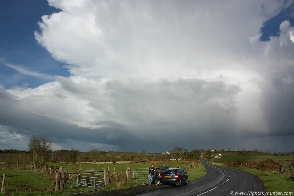 |
The mid level cloud dispersed and when we looked overhead we were stunned by the view of the storm's brilliant white anvil against a crisp blue sky. The anvil was so large that we couldn't get it into the frame of our cameras, on the video you can hear Conor and I discussing whether a 10-22mm or fish eye lens would be the best tool for the job, however we had neither so we had to wait for the storm to move further N before we could even get a portion of it in the frame. Here's the stretch of road we where parked on, the view was perfect with the lush bright fields contrasting with the blue sky and white anvil accompanied by plenty of strange looks from the occupants of cars which passed us on a regular basis, they were probably wondering why there where three guys standing around taking images of the sky.
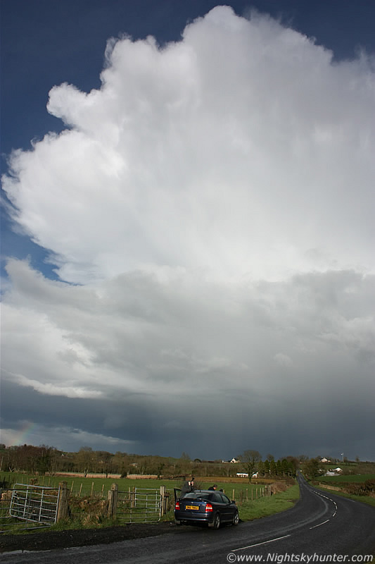 |
This was all happening between 17.00 and 18.00 BST. The above vertical image is 18mm wide angle which shows how high that anvil was, it's incredible to think that the temps up there were - 45 degrees C while at ground level we were very warm and comfortable in the sunshine.
 |
The precip core was now miles away yet I could only just get the entire anvil in the frame at this point. At first the anvil was mushy however it soon turned very solid indicating renewed cycles of growth and decent updraught strength. This scene was beautiful and really was the highlight of the day, we checked the sat images via Declan's lap top and were shocked to see 11 or 12 active cells over Ireland all at the same time, we didn't recall seeing anything like that for many years so things had certainly kicked off in a very lively fashion indeed.
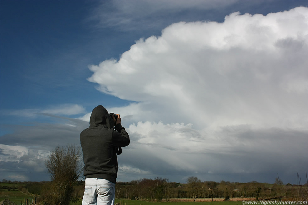 |
Here's Conor shooting the storm while standing on top of a gate with that beautiful sweeping anvil against a blue sky. It's important to imagine the bigger picture here, this storm was just one cell in a multicell storm which stretched in a SW-NE line from near Maghera all the way to the N/NE coast where the complex crossed the Atlantic Ocean. Our cell was the very rear cell or 'Tail End Charlie' if you like, so when you look at the above image just imagine a row of storm cells on the other side of this one for tens of miles in that direction, each with their own intense precip cores and lightning.
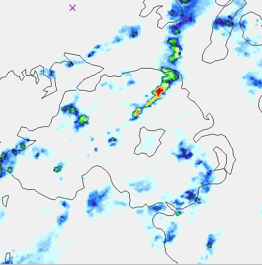 |
This is the high resolution radar from Netweather.tv showing strong echoes from that multicell line, the red echo to the lower L and N of Lough Neagh was our storm with the entire multicell covering a distance at least twice the length of the Lough so if you apply that knowledge to the anvil images above you can really appreciate the sense of size and scale. We drove back home at 18.00, I had plans that evening with my girlfriend so I needed to get ready, in the meantime Conor and Declan drove back out again after that storm and advanced further N while I drove S towards the Lough, I got a text message from Conor reporting more impressive rotation.
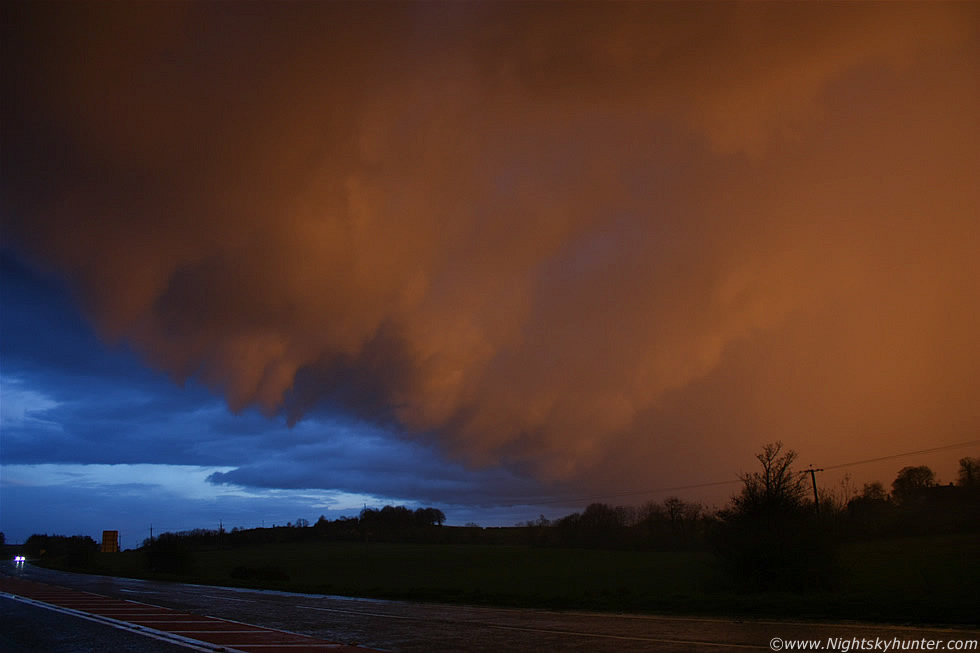 |
I picked up my girlfriend Roisin then drove back to Maghera however I hadn't eaten in hours and was feeling very tired so I wanted to stop somewhere for a snack so we decided to back track S again and get a KFC. While on the main carriageway near Castledawson roundabout we spotted this incredible sight creeping towards us so I quickly pulled over as quickly as I could to get images and video. This is a portion of a gust front on the leading edge of another cell, in this image it's moving R to L and about to pass over us, the dramatic cloud structure is part of the 'teeth' under the shelf, the colours in this image are all real, the sky looked like it was on fire just before sunset. I managed to snap 4 or 5 images before the precip blew in through the window soaking the camera. The drive through this core was interesting with very heavy rain mixed with hail and for a few min's the roads were completely water logged with significant surface spray and reduced visibility, at times it was difficult to see the road markings. The sunset which followed was quite remarkable, I hadn't seen a sky like it in years with vivid orange, red, and pink colours at play on spent showers and storms with strange structures. It was a great end to a great day and I was delighted Roisin was there to experience that dramatic gust front with me.
Here's a short video clip I made showing the storm over the housing estate followed by the nice anvil, near the end you can see the sunset gust front. I didn't catch any of the lightning however there are a few rumbles of thunder at the very start of the clip so the remainder is mostly cloud structure footage. I wish I had taken more video now that I look back on this. An excellent first storm outbreak of the season and I suspect this will be the start of a significant thundery Summer to come so I will be watching with interest. Thanks for reading.
Martin McKenna